
Before You Buy: How ISR Shapes Site Design and Development Potential
Before You Buy: How ISR Shapes Site Design and Development Potential
After zoning and FAR are understood, most investors assume the major constraints have already been identified.
But there is another layer that often has just as much influence on how a site ultimately performs and is developed.
It is called Impervious Surface Ratio, or ISR.
And while FAR defines how much building can be built, ISR defines how the land itself is allowed to function as a developed site.
In many cases—especially in Florida—it plays a major role in how a project is ultimately shaped.
ISR is about how the entire site performs, not just the building
Impervious Surface Ratio limits the percentage of a site that can be covered by non-permeable surfaces.
This includes:
Buildings
Driveways and parking areas
Walkways and patios (depending on jurisdiction)
Other paved or constructed ground surfaces
It may also include swimming pools and associated pool decks, as well as accessory structures such as gazebos, pool houses, and detached accessory buildings, depending on local code definitions.
In other words, ISR is not just about the building footprint.
It is about the total “developed surface” of the property.
This makes it a key factor in how the site functions as a whole—not just how much can be built on it.
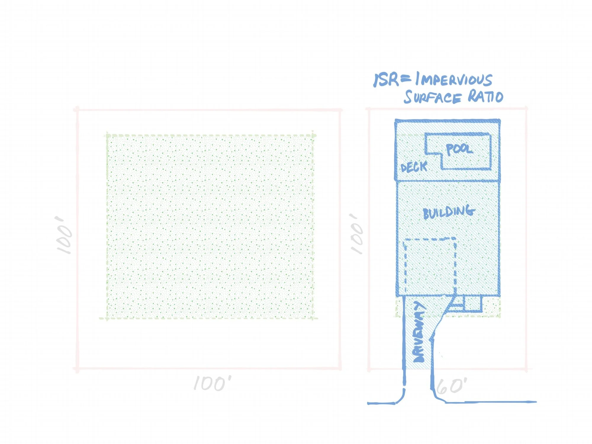
Different ISR for the same property may require alternative sizes and shapes for the pool area, the building, and the driveway. Here, a smaller driveway allows for a larger pool deck and building.
How ISR relates to real site performance
ISR is closely tied to how a property manages water, drainage, and long-term environmental performance.
In Florida, this becomes especially important due to the intensity of rainfall events. During typical summer thunderstorms—as well as longer-duration events such as hurricanes—large volumes of water can fall in a short period of time.
When a site has a high percentage of impervious surfaces, the ground loses much of its natural ability to absorb rainfall. That water must then be directed across the site through grading and stormwater systems.
If those systems are undersized, poorly coordinated, or overwhelmed by extreme rainfall, water can accumulate in low areas and increase the risk of ponding around buildings, site access points, and foundation edges. In severe events, this can contribute to conditions that lead to water intrusion at or near the structure.
For this reason, ISR is not only a regulatory limit—it is also a key factor in ensuring that a site can safely manage stormwater under real-world weather conditions.
When properly designed, impervious areas, drainage systems, and landscape zones work together to move water efficiently away from structures and toward appropriate discharge or retention areas.
How ISR shapes site layout and design decisions
Unlike FAR, which controls total building area, ISR directly influences how a site is physically organized.
Even when a building fits comfortably within allowable FAR, the project may still be constrained by how much of the site can be covered once parking, circulation, and outdoor areas are included.
ISR therefore plays a major role in determining:
where parking can be located
how driveways connect to the street
how buildings are positioned on the site
how much outdoor space remains
whether multiple units can realistically fit on the property
On many sites, ISR becomes one of the first constraints that influences the overall site layout during feasibility analysis.
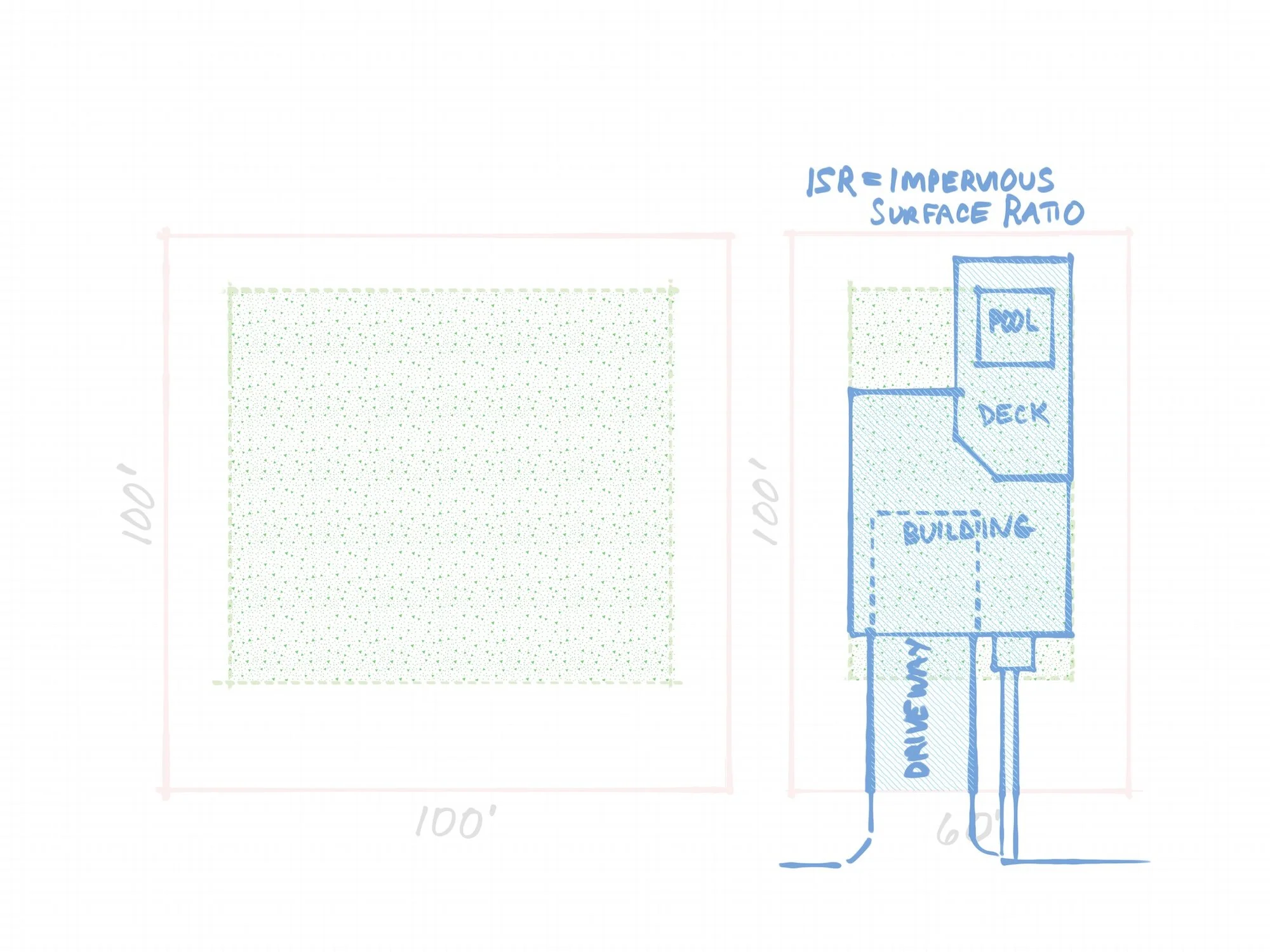
Different ISR for the same property may require alternative sizes and shapes for the pool area, the building, and the driveway. Here, the pool deck is minimized and the driveway width maximized.
Balancing development goals with low-maintenance site design
It is common for property owners and investors to request low-maintenance outdoor environments, often with minimal lawn and more usable paved space.
This is a valid design goal, especially in climates where traditional turf maintenance can be intensive.
However, low maintenance does not necessarily require maximizing hardscape coverage.
Well-designed landscapes can significantly reduce maintenance requirements while still preserving permeable areas that support drainage performance.
Drought-tolerant planting, gravel or mulch zones, and carefully structured planting areas can reduce irrigation and upkeep without fully converting the site into impervious surface.
This approach often results in a more balanced site that is both functional and compliant with ISR limits.
Swimming pools, patios, driveways, and accessory structures such as gazebos or pool houses all contribute to impervious coverage and must be carefully coordinated within the overall site plan.
The goal is not to limit outdoor living space, but to design it in a way that supports both usability and long-term site performance.
ISR and FAR work together, not separately
One of the most important aspects of feasibility analysis is understanding that FAR and ISR do not operate independently.
FAR controls how much building area is allowed.
ISR controls how much of the site can be physically occupied by buildings and constructed surfaces.
On many properties, these two constraints interact in a way that defines the true development capacity of the site.
A project may appear feasible based on FAR alone, but become constrained once ISR is applied to parking, circulation, and outdoor areas.
This is where early schematic thinking becomes essential in understanding what can actually be accommodated on a site.
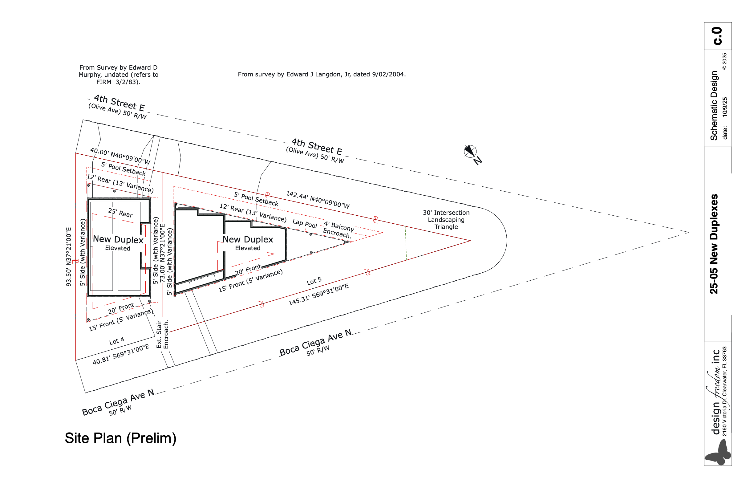
Site Plan showing property lines in red, setbacks (buildable area) in dashed red lines, proposed buildings in solid black, and proposed driveways and walkways in thin black lines. The ISR applies to the building, and any solid pavement within the property lines. It does not apply to the driveway apron or the portions of the driveway and sidewalk beyond the property lines.
This is where feasibility becomes three-dimensional
Once ISR is considered alongside zoning and FAR, the analysis begins to move from abstract code interpretation into physical site planning.
At this stage, it becomes possible to understand:
how the site can be organized
how much building and support area can fit
how circulation and parking will function
how outdoor space is balanced with development
Even with all of this understood, there are still additional factors that can significantly alter building form and site strategy.
One of the most influential—especially in coastal regions—is flood elevation and FEMA requirements, which often determine whether a building stays at grade or must be elevated above it entirely.
If you’re considering purchasing a property for a small-scale development, redevelopment, duplex, or missing middle housing project, a Feasibility Study can help clarify what is realistically possible before you commit to a purchase.
It provides a clear understanding of what the site can actually support—before you move forward with design or investment decisions.
If you’d like us to take a look at a specific property, feel free to reach out and we can walk you through the process.