
Before You Buy: What Flood Zones Mean for Building Height and Risk
In many parts of Florida, flood zones are not a secondary consideration in site planning.
They are often the first constraint that determines how a building must be designed.
Before zoning, before FAR, and sometimes even before site layout is considered in detail, flood requirements can define the basic question of whether a building can stay at grade—or must be elevated above it.
This has a direct impact on cost, construction type, and overall building form.
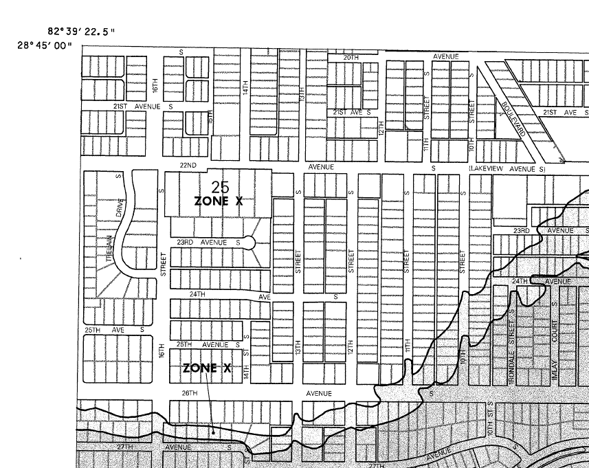
Example of a FEMA map showing Zone X. The unshaded (white) are areas of minimal flood hazard, while the shaded (gray) are areas where there is a chance of 500-year or 100-year flooding.
Every property is in a flood zone
One of the most common misconceptions is that only certain properties are “in a flood zone.”
In reality, every property is mapped within a FEMA flood zone designation.
The difference is in the level of risk and the associated building requirements.
Some properties fall within lower-risk zones where standard construction approaches may apply.
Others fall within higher-risk zones where elevation requirements and stricter construction standards become a central part of the design process.
Understanding which category a property falls into is one of the first steps in any feasibility study.
It is also important to note that FEMA flood zone maps in Florida were significantly updated in recent years using more accurate LiDAR-based elevation data. As a result, older maps should not be relied on for design or feasibility decisions.

FEMA Map showing AE flood zones, other flood hazard areas, as well as special zones along a Canal.
Understanding Base Flood Elevation (BFE)
Flood maps do not simply show whether a property is “in” or “out” of a flood zone.
They also establish a Base Flood Elevation (BFE) for many properties.
For example, a flood designation of AE-11 generally means:
A Zone = flood zone without wave action
11 = the required flood elevation relative to the North American Vertical Datum (NAVD)
The NAVD is essentially an established reference point used to measure elevation consistently across flood maps and surveys.
However, this number does not automatically tell you how many feet above the existing ground the building must be raised.
The only reliable way to determine that is through an Elevation Certificate (EC) prepared by a Surveyor.
The Elevation Certificate compares the actual surveyed elevation of the property to the required Base Flood Elevation.
This is one of the most important documents in evaluating a flood-zone property.
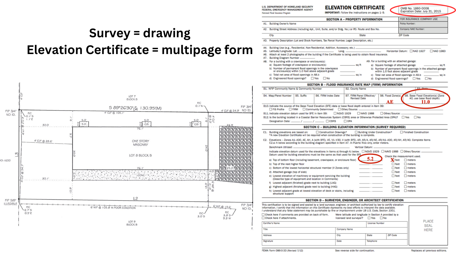
Example of a site plan or survey with its corresponding Elevation Certificate.
How to research flood elevation before purchasing a property
Before purchasing a property, it is worth checking whether an Elevation Certificate already exists.
Sometimes the property owner may have a recent EC available.
In other cases, cities or counties may keep Elevation Certificates on file for existing properties. Even if one is not available for the exact property, nearby homes can sometimes provide useful context if they were surveyed under similar conditions.
Another practical way to understand likely elevation requirements is simply to observe recent nearby construction.
In many Florida neighborhoods, newer homes clearly demonstrate how high builders were required to elevate living spaces above grade.
This can provide a valuable real-world reference point when evaluating redevelopment potential.
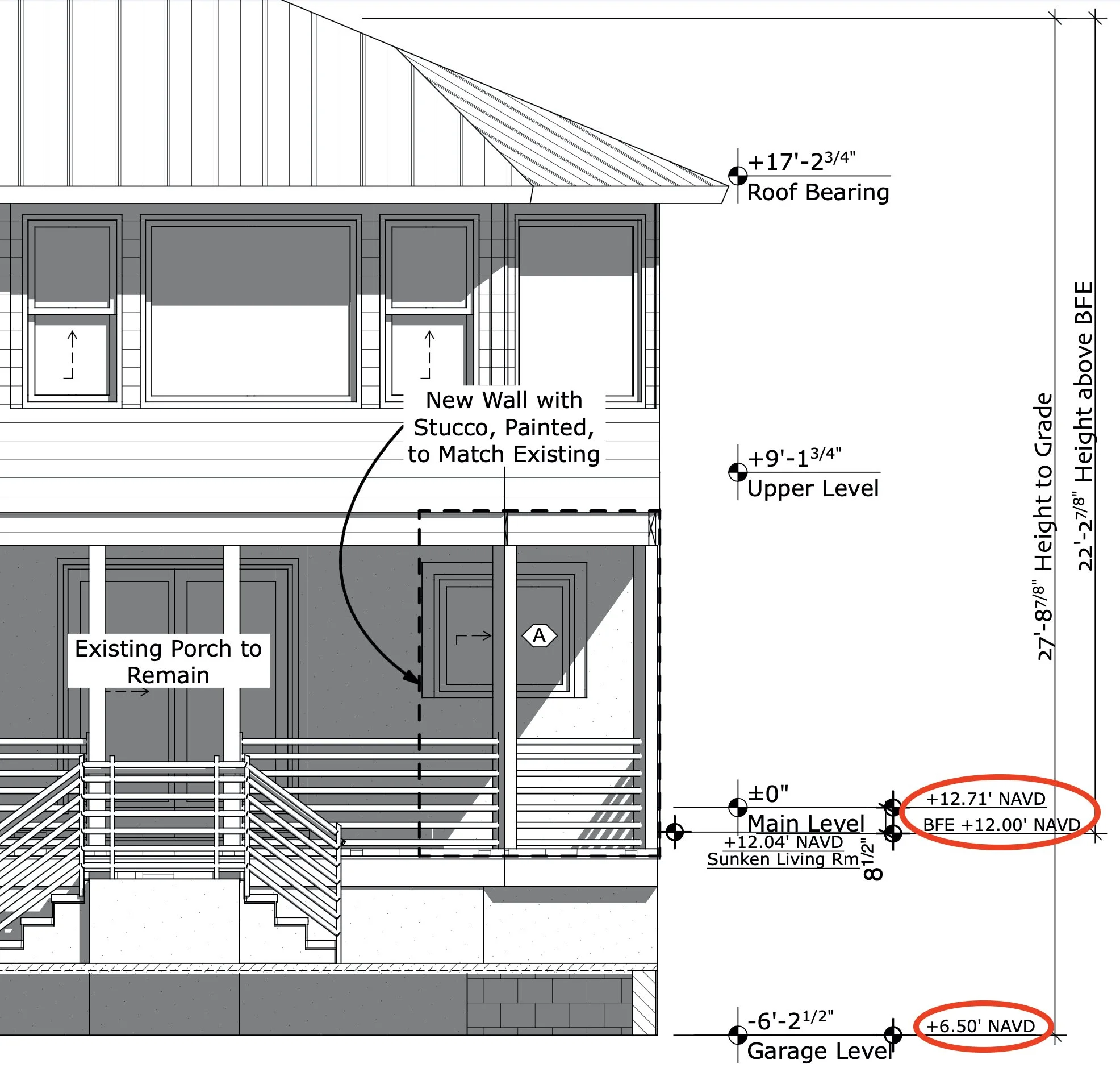
Elevation of a building showing the heights based on the Elevation Certificate.
Elevation often reshapes the entire building form
When a building must be elevated, the ground level is no longer used in the same way as traditional construction.
Instead, it typically becomes a crawl space or an open area used for parking and support functions.
Parking may take different forms depending on the design and local code:
an open carport (where walls remain open)
an enclosed garage
or a combination of both, integrated into the elevated structure
This creates a very different architectural condition than a typical slab-on-grade building.
Upper floors become the primary living space, which influences layout, circulation, and the relationship between indoor and outdoor areas.
In many cases, the ground level also includes a small conditioned entrance area with the front door, staircase, and sometimes an elevator leading to the primary living level above. Other projects may instead use an exterior staircase—either roofed or exposed to sun and rain—that leads directly to the first elevated living floor above parking.
What may initially appear as a one- or two-story building often becomes a raised structure with parking or crawl space below and living space above.
Can a site simply be raised with fill?
A common question from property owners is whether the building pad can be raised by adding fill dirt to bring the site above flood elevation.
In limited circumstances, this may be allowed.
However, in most cases, it is either restricted or heavily regulated.
One of the primary concerns is that raising a site artificially can displace stormwater and increase runoff onto adjacent properties. For this reason, floodplain and stormwater regulations are designed to prevent unintended impacts to neighboring sites.
As a result, elevation is typically achieved through structural design rather than large-scale site fill, especially in coastal or tightly regulated areas.

Photo from FEMA showing boat displaced to a road median.
Real-world conditions can exceed mapped flood elevations
While FEMA flood maps and Elevation Certificates provide the regulatory baseline, they do not always reflect localized or extreme conditions.
In practice, some areas experience flooding that exceeds mapped expectations during major storm events.
For example, in certain coastal neighborhoods with nearby canals or drainage systems, recent hurricane or storm events have resulted in slab-on-grade homes experiencing significant interior flooding—sometimes reaching several feet above finished floor levels.
Even if current flood maps indicate that only modest elevation above grade is required, real-world conditions may suggest a higher level of resilience is appropriate.
For this reason, it is often advisable to consider both regulatory requirements and observed local flooding history when evaluating a property.
In some cases, raising the finished floor above the minimum required elevation may provide significantly better long-term protection and resilience.
Flood zones as a defining design condition
Rather than viewing flood zones as a limitation, it is more accurate to understand them as a defining condition of the site.
They establish:
where the building can safely exist
how it must be elevated
and how the structure interacts with the ground plane
In coastal Florida, this often becomes one of the most important drivers of architectural form.
The result is not a constraint on design, but a framework that shapes it from the beginning.

Click image to be taken to a download page on our website.
Additional resource: FEMA Primer for Investors
Because flood zones, elevation requirements, and FEMA terminology can feel overwhelming at first, we also provide a separate educational guide that explains many of these concepts in more detail, including flood zones, Base Flood Elevation, Elevation Certificates, and resilient rebuilding considerations for Florida properties.
If you are evaluating property in a flood-prone area, this primer can help you better understand the terminology and decision-making process before purchasing or rebuilding.
This is where feasibility becomes fully dimensional
At this stage in the feasibility process, the site is no longer defined only by zoning or square footage calculations.
It is defined by a combination of:
what is allowed (zoning)
how much can be built (FAR)
how the site can be covered (ISR)
and how the building must respond to elevation and water
Together, these factors determine the true physical potential of a property.
This is why flood-zone properties require a different level of early analysis than many buyers initially expect. The most successful projects are typically the ones that understand these constraints from the beginning and use them to shape smarter, more resilient design decisions rather than trying to work around them later in the process.
If you’re considering purchasing a property for a small-scale development, redevelopment, duplex, or missing middle housing project, a Feasibility Study can help clarify what is realistically possible before you commit to a purchase.
It provides a clear understanding of what the site can actually support—before you move forward with design or investment decisions.
If you’d like us to take a look at a specific property, feel free to reach out and we can walk you through the process.